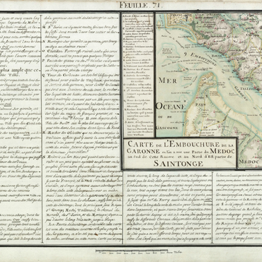
Legend has it that the island of Antros was suspended on the sea, rising and falling with the tide and giving the impression that it floated. In the first century CE, Roman geographer Pomponius Mela placed Antros at the site occupied by the island of Cordouan. He explained this belief by the fact that, during floods, the waters covered the adjacent lands; only the island floated free, dominating its surroundings. This phenomenon was all the more astounding as, according to some, the island was in fact attached to solid ground, and that it was the only visible object when the water level rose. The belief that the island of Cordouan was Antros persisted, notably in Gabriel de Lurbe's Chronique Bourdeloise from 1617. Louis Moreri, in his 1674 Dictionary, defined Antros as "a small island where the Cordouan tower is built." Later, the royal engineer Claude Masse, who mapped the Gironde and the region of Saintonge in the eighteenth century, spoke of the "île d'Antrosse", which had once covered the Cordouan plateau. Cordouan's connection with terra firma at the Pointe de Grave, which explains the assimilation with Antros, is attested to by the problems of bringing building materials to the worksite by boat. And yet, this is just what Louis de Foix did in 1584, invalidating the main argument of the hypothesis. The principal changes around the island involved the sandbanks increasing in size, making access to Cordouan more and more difficult, a phenomenon confirmed by the church at Soulac being surrounded by sand dunes in the eighteenth century.
Associated media
Open Media Library