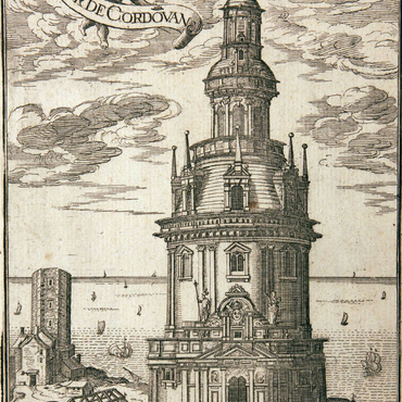
Claude Chastillon was born in Châlons-en-Champagne, was appointed royal topographer in 1591, and was made engineer in 1595. He lived in Angoumois, Aunis and in Saintonge in 1604. In 1606, Sully sent him on a mission to Guyenne to carry on the work underway at Cordouan. It was Chastillon who produced the map of Cordouan entitled Griffonnement and a drawing of the Cordouan tower, which was turned into an engraving. The first known engraving dates to 1633; it was published in a volume by geographer Christophe Tassin, Plans et profils des principales villes de la province de Guyennne. The anonymous engraving added an angel holding a scroll presenting the lighthouse. However, the most widely-known engraving was published in 1641 by Poinsart in Topographie française. Engraved by Mathieu Mérian and entitled Lexelent bastiment de la Tour ou Phanal de Cordouan, it is considered to be one of the finest images in the collection. The non-architectural details in the background – boats, fishing scenes, sea monsters, etc. – are the work of Mérian, and give an idea of the desire of the engraver and the publisher to liven up the plate. The architectural representation is taken from Claude Chastillon's meticulous work. In 1642, captions for the Tower were added to the 1641 edition by Jean Boisseau, royal illuminator. An edition from 1705, published by Fer and engraved by Cocquart, offers a new, horizontal presentation of Chastillon's drawing. The plate is flanked by a map and a cross-section of Cordouan. The scenes around the lighthouse are fewer and more toned down than in previous editions.


