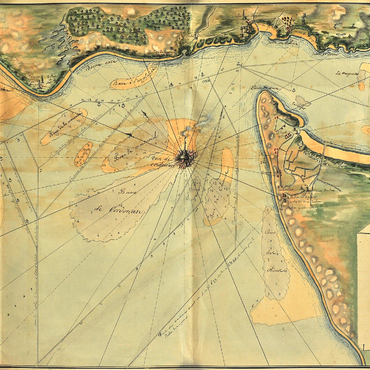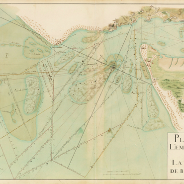
Teulère made developing the "river of Bordeaux" and making it safer a part of his mandate, particularly the mouth of the river, which was its trickiest and most dangerous section. In the late eighteenth century, the need to put more high-powered navigational aids in place focused on raising the tower and making its light more visible further out to sea. The first task associated with this was a device Teulère set up at the entrance to the Gironde simulating the greater reach of the light from a taller lighthouse. Precise, reliable charts of the estuary, of its narrow and tortuous straits, and of the daymarks and alignments to follow needed to be drawn up. Successive charts had been established throughout the preceding century, and a network of markers (tall steeples, wooden markers and stone towers) had been built along the coasts. Teulère, wanting to draft an overall, integrated plan of the waterway's markers, began to meticulously map the estuary. Working in collaboration with the river's pilots – who were the best guides to the estuary's pathways and hidden dangers – he carried out a series of hydrographic surveys of the waters and topographic surveys of the shoreline. He thus created two charts of "the entrance to the river of Bordeaux" in 1787 and in Year VIII (1799): "surveyed at various times since 1776 and verified at Royan by coasting-pilots." These extremely detailed and coloured charts, with their precise drawings of straits, routes to follow with their alignments, and vignettes representing all of the daymarks, constituted a genuine nautical manual and practical handbook for navigating up and down the Gironde. Of course, Cordouan appears, at the centre of the river's mouth, a prominent daymark that ships could use to take their bearings before entering the straits of the "river of Bordeaux".